Yes there are some really nice Celtic descriptive place and river names in Wales and elsewhere in Britain. Even in some relatively mundane settings. Here’s one to whet your appetite: The Malago is an urban small river, running through Bristol, partially culverted.
Mal- from melis/melin for Mill
-agos from close to as all SSiWers will know
The majority of Welsh place names, at least here in the North West of Wales, are just physical descriptions of the location. This why you get so many places called Talybont/Tal-y-bont, Pwllglas or Glaslyn and old houses called things like Ty’n Twll, Hafodty Fach or Ty’n y Berllan.
Maybe the original placename Aberystwyth was further out in Cardigan bay and has moved back in-land over time to the other side of the Rheidol, because of Coastal erosion?
I read on Wikipedia that the first Norman fortress was 1.5 miles to the South on the other side of the Ystwyth and what is now Aberystwyth town was called something else.
The mouth of the ystwyth was also moved when the harbour/port was built as well.
Aber is not really estuary - it’s just where a river empties into another body of water, which could be another river or could be the sea. Hence Aberhonddu, Aberedw, Abernant all near (ish) me.
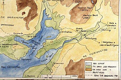
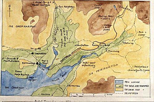
Yes, in particular the Cob embankment at Porthmadog resulted in a huge reclaiming of land around Porthmadog and Tremadog and much of the Glaslyn Estuary.
Before:
Gosh! Is that stable reclaimed land, or is it likely to be lost in any future flooding,?
Or require continuous flood defence work?
As @louis will know “God made the world, but the Dutch made Holland” Perhaps the same is true of the Welsh, and pethaps there is a bachgen bach somewhere with his finger in a dyke.
The cob was built in 1812 so it’s done pretty well, although there have been various widening works done to it since. Also the recent Porthmadog bypass has added to the flood defences (it’s raised up on it’s own ‘dyke’!), but having said that, the area is still pretty flood-able today - the sogginess isn’t that far below the surface in many areas and the areas up the Glaslyn Valley especially flood very easily after heavy rain. Very often the B4410 between Prenteg and Llanfrothen is unpassable.
Having worked on a programme about William Maddocks and the Cob a few years back and currently working on one featuring flood defences in South Holland, this has turned out to be a pretty serendipitous thread!